AMBOSELI CONSERVATION PROGRAM
​Connecting skills to advance conservation knowledge and applications
  • Home
  • About ACP
  • The Amboseli Ecosystem
  • Collaborators
  • Library
  • News & Commentaries
  • Contacts

An analysis of livestock price fluctuations with droughts in eastern Kajiado

1/31/2020

 
Picture
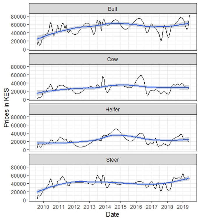
Figure 1: Average livestock market prices in eastern Kajiado showing a steady recovery after the 2009 drought and fluctuations with subsequent dry periods.
By Victor N. Mose, David Maitumo, Winfridah Kemunto , Erastus Mwaniki, Paul Kasaine, Sunte Kimiti, Samuel Lekanaiya and David Western
 
The livestock market in eastern Kajiado has steadily recovered after the near collapse in 2009 owing to the debilitating drought that led to losses of cattle, sheep, goats and donkeys. Prices fell below 1,000 Kenya shillings for a bull too weak to walk and surged to 90,000 Kenya shillings with the drought breaks (Figure 1). Amboseli Conservation Program monitors  livestock  market prices  on a monthly basis and is in the process of modelling economic losses due to droughts and the gains when herders sell off their livestock early enough before  periods of extreme  forage shortfall.
​
A calibration of livestock prices based on monthly  data collected in the ecosystem from 2009 to 2019 shows that  the  average prices for bulls in 2009 were in the red (Figure 2) falling 80.1 percent below the maximum expected market price. The market recovered steadily up to  2014 with arrival of widespread rainfall  and oscillated with seasonality thereafter.
The early warning model can guide herders on when to sell off their livestock  based on forage conditions and market forces, while estimating economic losses  due to extreme drought.

Picture
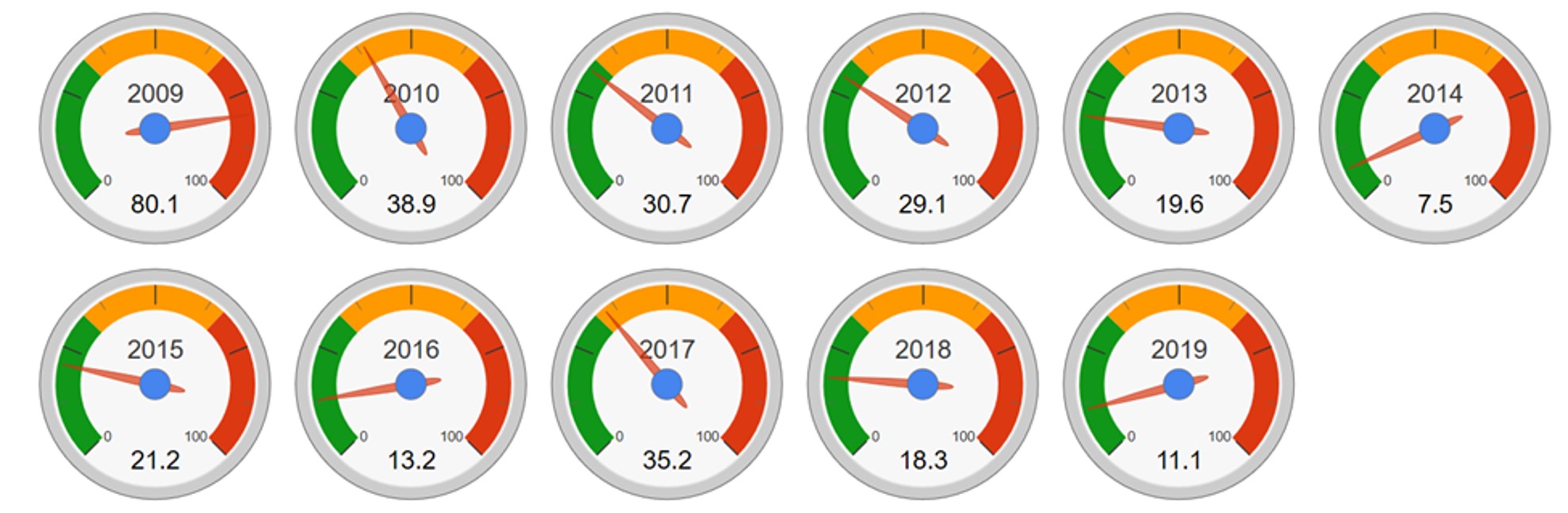
Figure 2: Price gauges showing average bull price index in percentages below the maximum price ever recorded. The prices, in the red during the 2009 drought, fell 80 percent below the maximum before recovering steadily up to 2014.
Picture
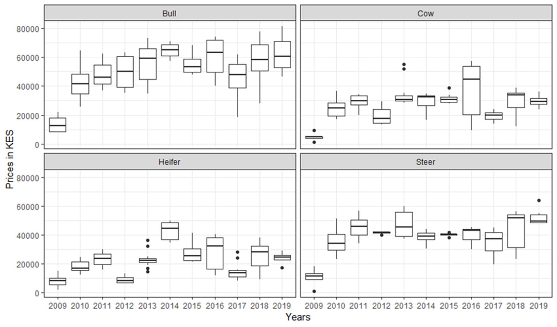
Figure 3: Annual variations of the livestock prices from 2009 to 2019.

The subdivision of Ogulului Group Ranch: Does it spell doom for Amboseli’s wildlife?

1/8/2020

 
By David Western
 
Ololorashi-Ogulului Group Ranch (OOGR), which surrounds Amboseli National Park, supports most of its migratory wildlife in the wet season. The ranch has recently begun subdividing the 330,000-acre ranch among its 5,000 members.
 
Conservationists are deeply concerned, fearing there is no place for wildlife on small subdivided lands, and with good reason: ten years ago, Rosemary Groom and I called attention to the steep decline in wildlife following the subdivision and degradation of the Kaputei group ranches north of Amboseli [1]. Today the once large seasonal migrations of wildebeest and zebra have vanished. Wildlife in Amboseli faces a similar fate if OOGR ranch carves up and settles the migratory routes across the ecosystem.
 
Parks are no panacea for conserving wildlife; numbers are declining in lockstep with losses in the surrounding lands and across Kenya as a whole [2].
 
How real is the threat of OOGR to the future of Amboseli’s wildlife and the national park?  
 
The subdivision of the Amboseli ecosystem into Kaputei-like settlements reflects a far large threat to Kenya’s rangelands. The Ministry of Lands in 2019 declared that all community lands are open to adjudication into private allotments, opening the floodgates to the fragmentation and degradation of Kenya’s savannas and pastoral livelihoods.
The push for the subdivision of OOGR has been building for two decades. The pressure stems partly from a fear of land grabs, partly from the economic and social transition from subsistence pastoralism to settled livelihoods. The push has been held back by the group ranch and political leaders cautioning members about the dangers of carving up the open rangelands into plots too small to support a family, and the dangers of outsiders and land speculators buying up the pastoral lands. The leaders point to the fate of Kimana Group Ranch adjacent to Amboseli as a warning. Following subdivision, most of the land was sold to settlers and farmers.
 
I recently visited the American prairies, which were carved up into similar small parcels in the 1920s, to gauge the risks of subdividing Kenya rangelands. (See A visit to the American Dust Bowl 80 years on: Lessons for the African Savannas). The visit convinced me that family herders and farmers in the African savannas face a similar fate unless the allocation of title deeds takes account of the health of the land.
To avoid Amboseli and Kenya’s rangelands going the Kaputei and Dust Bowl way, OOGR must ensure its members can secure title to their lands without destroying them for livestock and wildlife alike. In short, OOGR is a testcase for future of Kenya’s pastoral lands.
 
Caught between the pressures for subdivision and concerns over land degradation and sales to outsiders, OOGR has held lengthy discussions over the years to find a balance between land security, settlement, viable family herds and wildlife conservation. A draft plan was presented to wildlife conservation organizations in 2014, soliciting inputs. The final plan, a 100-page document prepared by consultants, was completed early in 2019, approved by Kajiado County and released at a workshop which included the Kenya Wildlife Service and conservation organizations.
 
In summary, the 330,000 acre OOGR group ranch is being subdivided among its members into four zones: 1) ten village service areas where each member is allocated a quarter acre for settlement and provided social services; 2) a pastoral grazing areas where each member is allocated 21 acres; 3) four wildlife conservation areas to allow free wildlife movements and within which each member is allocated a nominal 8 acres, and 4) farming allocations in the Namelok area east of Amboseli National Park which have already been allocated and developed. Permanent settlements and fencing will be prohibited in the pastoral and wildlife areas in order to sustain seasonally mobile livestock keeping under the existing OOGR grazing plan. A caveat on each title deed will bar permanent settlement, fencing and land sales for 99 years.
 
The chairman of OOGR, Daniel Leturesh, stated in his presentation to conservation NGOs that Ogulului intends to set up a trust to manage pastoral and wildlife areas and invited discussion on how it might operate and the role the NGOs might play. Both Kajiado County and national government planners consider that the OOGR might offer a way to grant individual title deeds to Kenya’s extensive rangelands yet keep them open for pastoralism and wildlife.
 
On 7th August the Amboseli Ecosystem Trust (which represents all seven group ranches in the ecosystem) presented the OOGR plan to conservation organizations working in the region. The workshop was attended by twenty-five conservation organizations and the Kenya Wildlife Service. Jackson Mwato, coordinator of AET, presented the background to the plan. I was asked to cover the ecological considerations drawing on ACP’s fifty years of monitoring data. The findings showed wildlife migrants moving wildly across the ecosystem in in response to erratic rainfall. The dry season concentration area and wet season dispersal of the wildlife and livestock migrants define the Minimum Viable Conservation (MVCA), which the Amboseli Ecosystem Management Plan 2020-2030 is using to define the ecosystem.
So far, the MVCA has remained open to livestock and wildlife movements and the population sizes of the migratory species, including zebra, wildebeest and elephants,  which hare determined largely by the forage availability in the woodlands and swamps of Amboseli National Park, have been sustained.
 
The main goals of the OOGR plan are to ensure community development, pastoralism and wildlife populations. Provided it does ensure the continued seasonal mobility of wildlife and livestock populations, it can achieve the three objectives. Key to  its success is a rotational livestock grazing plan designed and adopted by OOGR. The grazing plan aims to restore pasture production and reverse land degradation. If maintained, individual land holdings need not impair wildlife and livestock movements. If, however,  , land titles lead to permanent settlement on each plot, the rangeland will deteriorate rapidly and cause a rapid decline in wildlife, family herds and the pastoral economy.
 
The conservation organizations issued a statement at the end of the meeting on 7th August recognizing the right of the landowners to decide the use of their land and taking a neutral position on the plan, except to express their commitment to conserving Amboseli as a unique wildlife area of national and international significance.
 
The OOGR subdivision and zoning plan met resistance from a political faction of the group ranch, claiming there has been insufficient consultation. The protestors burned down the International Fund for Animal Welfare’s rangers camp and tourist facilities, then attempted to burn down Nongotiak Centre. The warriors involved were thwarted by the community and arrested by police. Following intensive negotiations and community meetings, the rival factions have since reached agreement on how to move ahead.
 
Whether the plan will strike a balance between granting individual land titles and sustaining pastoral herds and wildlife hinges on winning the agreement and compliance of its members on the type of governance to replace the dissolution of group ranches. In anticipation of subdivision, ACP and ACC have been in discussion with the OOGR leaders and AET over the last two years. The trust now assumes great urgency.
 
The rapidity of OOGR’s subdivision calls for urgent action to ensure a lands trust does replace the group ranch before its dissolution. On a positive note, the Amboseli Ecosystem Management Plan 2020-2030 was vetted and adopted on 11th December by all group ranches, KWS and conservation organizations working in the ecosystem. (See Amboseli Ecosystem Management Plan 2020-2030 ratified and adopted, 7 January 2020). The adoption of AEMP signals a strong commitment of all parties to sustaining the vitality of Amboseli’s wildlife as an integral part of the region’s development plans.
 
OOGR has signaled its intention to explore the prospects of a land trust under the umbrella of AET. ACC and ACP are also consulting other conservation organizations, the Rangeland Association of Kenya and government agencies on the prospects of land trusts serving the interests of  pastoral communities across the rangelands in order to avoid the fragmentation and degradation of Kenya’s rangelands. 

References

[1] David Western, Rosemary Groom, and Jeffrey Worden, “The Impact of Subdivision and Sedentarization of Pastoral Lands on Wildlife in an African Savanna Ecosystem,” Biological Conservation 142, no. 11 (2009): 2538–46; Rosemary J Groom and David Western, “Impact of Land Subdivision and Sedentarization on Wildlife in Kenya’s Southern Rangelands,” Rangeland Ecology & Management 66, no. 1 (2013): 1–9.

[2] David Western, Samantha Russell, and Innes Cuthill, “The Status of Wildlife in Protected Areas Compared to Non-Protected Areas of Kenya,” PloS One 4, no. 7 (2009): e6140.

Amboseli Ecosystem Management Plan 2020-2030 ratified and adopted

1/7/2020

 
PictureRepresentatives of partner organizations and community members at the workshop in Machakos. (Photo by Solonka)
By David Western

The Amboseli Ecosystem Management Plan (AEMP) 2020-2030 was ratified and adopted at a workshop in Machakos on 11 December after many meetings of the Project Implementation Committee, partner organizations and community members over the last eighteen months. The plan replaces the first AEMP covering the period 2008 to 2018. In the next few weeks the new plan is expected to be formally adopted by county and government agencies and gazetted by the Attorney General. AEMP, the first of its kind to incorporate wildlife and natural resource management into a broader planning framework, lays out a framework for sustaining the land health of the rangelands throughout Kenya and beyond. Amboseli Conservation Program (ACP) prepared the main report on the Amboseli ecosystem undergirding AEMP 2020-2030.
The  following is a summary of AEMP 2020-2030 outline of the 151-page plan:

The Plan

The vision for the Amboseli Ecosystem: “To sustainably manage and utilize the ecosystem’s natural resources for community livelihood improvement”
​

The Amboseli Ecosystem Management Plan is an integrated plan that outlines how different land uses and natural resources in the Amboseli Ecosystem will be managed for the greater good of all stakeholders. The renewal of AEMP 2008-2018 for a further 10 years is a clear indication that the stakeholders, who include landowners, KWS, NGOs, the tourism industry and researchers, are committed to an ecologically viable Amboseli Ecosystem. The plan takes a broad multi-sectoral view of all the natural resources in the ecosystem against different land uses and how these interact with one another and, ultimately, how they co-exist within the ecosystem. 

The Amboseli Ecosystem Management Plan 2020-2030 is the second AEMP after the lapse of the first ten-year AEMP 2008-2018. This AEMP incorporates lessons learned during the implementation of the first AEMP. It is a product of broad-based consultations among diverse stakeholders beginning with government entities of national and county levels, the group ranches, NGOs, Hoteliers and Tour Operators. The stakeholders and especially the CPT who were the Plan Implementation Committee (PIC) members of the first AEMP, brought up diverse views, expertise and a plan foundation report describing biophysical and social components necessary to achieve the desired future conditions for community livelihoods, ecology, tourism, and institutions and governance systems in the Amboseli ecosystem. The report set out the strategic principles and socioecological relationships, and rationale for development of the new AEMP.
​
The plan foundation report was an update of a previous report that was used to develop the AEMP 2008-2018. It pinpointed threats to the productivity and viability of the Amboseli ecosystem and national park, the main threats, such as increasing farming, settlement, fencing, subdivision, water extraction from rivers and swamps, the loss of seasonal grazing grounds and drought refuges for livestock and wildlife, and heavy grazing pressure which was reducing the productivity and resilience of the ecosystem. The threats also included bush meat poaching, a breakdown of migrations and compression of wildlife (elephants especially) into Amboseli National Park, and the resulting loss of habitat and species diversity. It further recommended specific actions to combat the threats and the creation of Amboseli Ecosystem Trust (AET) to oversee the implementation of the plan. The updated report is the foundation of the new AEMP, and Amboseli ecosystem stakeholders built on this foundation to develop the new plan.

The AEMP 2020-2030 has a wide scope which includes livestock development, rangeland and water management, agriculture, permanent settlements, and urbanization and new enterprises. It also addresses the changes over the last decade and the threats to the ecosystem. These threats include land subdivision, agricultural expansion, water extraction for farming and other commercial activities, loss of seasonal pastures, and the growing impact of grazers and browsers on habitat, species diversity, and plant production and on livestock and wildlife populations.

 As a follow up of the AEMP 2008-2018, the aim of which was to maintain habitat connectivity and safeguard the viability of the Amboseli migratory wildlife populations, the new AEMP strives to maintain and restore ecosystem integrity to safeguard Amboseli’s wildlife and community livelihoods based on the Minimum Viable Conservation Area. The ecosystem plan also spells out the role of AET and partnering organizations in presiding over the plan implementation, and defines the central role of the Noonkotiak Resource Centre as the information and research hub of the ecosystem, coordinating ecosystem monitoring and planning, setting up an information database, tracking and adapting management plans and developing a visitor and cultural centre and education outreach program.

The AEMP 2020-2030 integrates the land use plans of the seven group ranches, Olgulului/Ololarashi, Mbirikani, Eselenkei, Kuku, Rombo, former Kimana group ranch and Amboseli National Park. Group ranch land-use plans have been developed to minimize land use conflicts and enhance community livelihoods. The plans consider facilitating conservation of viable wildlife populations at the ecosystem level by planning for wildlife migratory routes and critical refuges. They also include restoring degraded lands through “Olopololi” (grass banks), resting and rotation of pasture use, soil erosion control measures and establishment of wildlife conservancies.  

    Amboseli Conservation Program

    Archives

    March 2023
    February 2023
    January 2023
    December 2022
    November 2022
    October 2022
    August 2022
    June 2022
    May 2022
    March 2022
    February 2022
    October 2021
    July 2021
    December 2020
    November 2020
    August 2020
    July 2020
    April 2020
    March 2020
    February 2020
    January 2020
    October 2019
    August 2019
    May 2019
    April 2019
    September 2018
    June 2018
    February 2018
    December 2017
    May 2017
    April 2017
    January 2017
    December 2016
    July 2016
    April 2016
    December 2015
    October 2015
    September 2015
    August 2015
    June 2015
    April 2015
    February 2015
    January 2015
    April 2014
    November 2013

    Categories

    All

    RSS Feed

Powered by Create your own unique website with customizable templates.