The power of visualizing spatial and temporal data in developing and testing ecological hypothesis4/1/2019
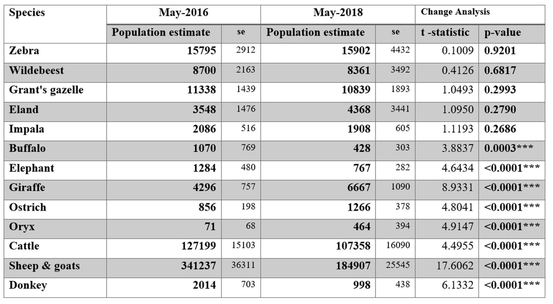
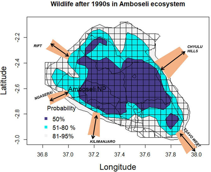
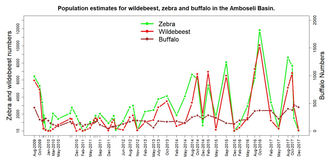
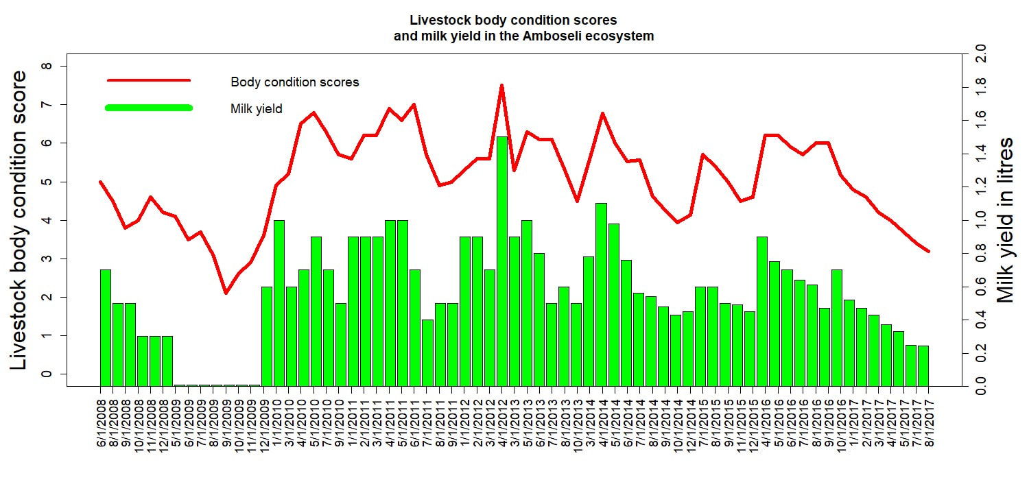
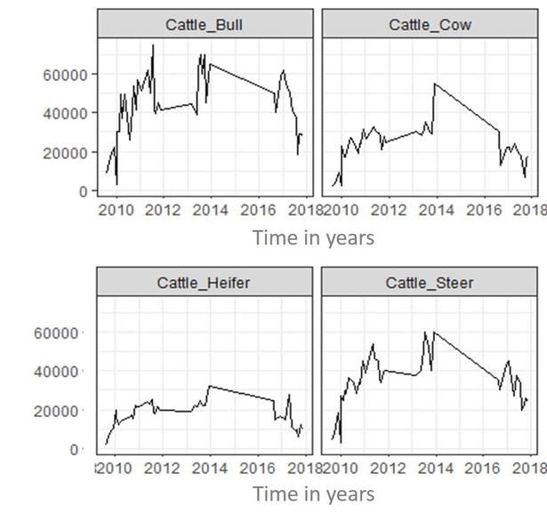
Using exploratory data analysis to visualize and test hypothesis is fast becoming a method of choice for many researchers working across disciplines. Data visualization allows team members to work together in building ideas about how ecological systems work. Victor Mose outlined the benefits of this approach at the third annual International Biometric Society (IBS)–Kenya chapter held at the Strathmore University in Nairobi. He used the long-term Amboseli data to show how spatial exploratory data analysis can reduce complex ecological hypothesis to simple visual presentations with cross-cutting research applications. The approach requires no prior knowledge about the data and can be rapidly applied to formulate and test hypothesis in visual form with wide applications.
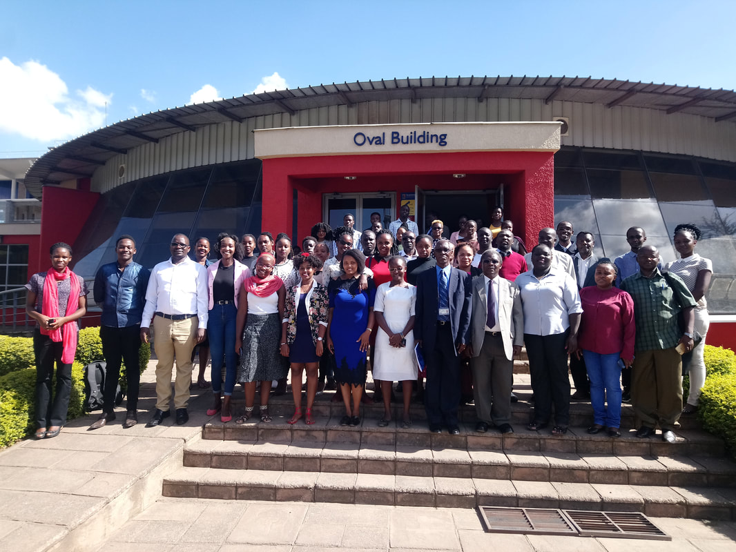
By Victor N. Mose
Following the launch of a digital platform to collect animal and plant data by Amboseli Conservation Program (ACP) last year, the Resource Assessors (RAs) were due for advanced training in the use of digital platform. This platform now includes livestock herd follows, milk production and market prices recording and general livestock value chain monitoring. In the first week of September 2018, ACP trained all the RAs working in the Amboseli area on the upgraded tool during a two-day workshop at African Conservation Centre (ACC) offices in Karen, Nairobi. The training covered field data capture, checking and online transmission to computer servers at ACC and the processing of results using R scripts for tabular and graphical summaries. The upgraded platform build on Open Data Kit is more user friendly with meaningful prompts that allow data validation during entry. At the workshop, RAs and trainers had good discussions and lots of questions asked. The Chairman, ACC encouraged RAs to advance to professional levels in rangeland monitoring through resource assessing. Data Dissemination The next step is to implement information feedback to communities based on data collected and to present the analyzed results in a highly visual format that encourages community uptake and decision support, starting at the household level. The presentation model is based on an open source platform for biodiversity conservation and natural resource management as presented by Mose Victor, Western David and Tyrrell Peter., 2018. (download paper here). ACP commissioned the Department of Remote Sensing and Regional Surveys to conduct a wet season count of the Amboseli ecosystem in May to take stock of the populations of wildlife and livestock after two years of drought. As reported in earlier ACP web postings, the drought caused the death of livestock and some wildlife species at the tail-end of the long dry season in September and October of 2017. Given the poor short rains in November and December, we expected drought losses to mount in the January to March dry season this year. The losses were, however, stemmed by unseasonal rains in January and again mid-March.
A comparison of the 2018 counts with the 2017 count prior to the prolonged two-year dry spell shows that, despite the deaths of zebra, wildebeest and buffalo recorded around the Amboseli swamps last September and October, wildlife populations survived the dry years very well. A table comparing the two counts (below) shows zebra, wildebeest, grant’s gazelle, eland and impala numbers holding their own. Buffalo numbers showed a decline on the aerial counts, but the losses were not evident in the monthly ground counts conducted in Amboseli. Elephant numbers in the ecosystem were down significantly. The decline reflects emigration to surrounding areas rather than mortality, given that few deaths were recorded. Giraffe, ostrich and oryx, all drought-hardy species, increased over the past two years. The increase in giraffe is especially encouraging, given its decline across its range in Africa and its recent classification as a threatened species. The increase is due largely to containment of bush meat poaching in the Amboseli ecosystem over the last few years. The losses of cattle, sheep, goats and donkeys, on the other hand, are confirmed by the mortality records from ground surveys during the drought. Based on our monthly vegetation plots, we expected far larger losses of wildlife than actually occurred. The wildlife survival we attribute to boost in fresh pasture created by spread of surface water in the swamps in the last two dry seasons. The losses among cattle, sheep and goats was due to the large sizes of their populations and the limited access they had to late season grazing taken up by farms and settlement. Over the years ACP, together with its partner organization, the African Conservation Centre, has taken on and trained over 35 promising conservationists and conservation scientists. Among them was John Waithaka, who conducted his PhD on the impact of elephants on habitats under David Western. John was later appointed coordinator of elephant programs then director of the Biodiversity Division at Kenya Wildlife Service. John went on become director of ACC before being employed by Parks Canada for fourteen years. On retiring from Park Canada, John returned to Kenya in 2017.
We are pleased to announce that John was appointed the new chairman of the Kenya Wildlife Service on June 1st following the end of Dr. Richard Leakey’s 3-year tenure. John will bring a wide range of experience to his new position and we offer him all our support. In further government announcement by the Cabinet Secretary for Tourism and Wildlife, David Western was appointed to the Wildlife Utilization Task Force in March 2017. The task force is charged with looking into the pros and cons of various forms of wildlife utilization, including game farming, covered by the Wildlife Act. Sport hunting is banned under the Act and is not under consideration. In March Sakimba Kamiti, who conducted his Master thesis with ACP, was appointed field coordinator to the joint ACC--University of Lyon 3-year research program into the human dimensions of wildlife and ecosystem changes in Amboseli. Sakimber has also been accepted to PhD candidacy at the University of Lyon, working in collaboration with ACP. The Amboseli Ecosystem Management Plan (AEMP) was initiated by ACP and ACC in 2004 to urge the Maasai landowner association to call on Kenya Wildlife Service, other government agencies, conservation organizations, tourism industry and researchers to draw up a conservation plan for the Amboseli ecosystem.
The effort led to the launch a ten year AEMP plan for 2008 to 2018. The aim of ecosystem plan, the first of its kind, was to maintain the viability of the Amboseli migratory wildlife populations. The plan recognized that pastoral herders also moved seasonally in much the same way as wildlife. With this mind, AEMP defined a Minimum Viable Area for sustaining wildlife and pastoral herds, the threats to the integrity of the ecosystem, and proposed specific mitigation measures. The renewal of AEMP for a further 10 years is currently underway. ACP has, as in the original planning process, drawn up a detailed report providing the background materials for the new. The report was completed in April and submitted to the planning committee overseeing AEMP 2018-2028. The ACP report points out that the new plan must take into account the recommendations of the Strategic Environmental Assessment commissioned by the Amboseli Ecosystem Trust and gazetted by the National Environmental Management Authority. The new plan must also include plans for livestock development, rangeland and water management, agriculture, permanent settlements, and allow for urbanization and new enterprises. The plan should also address the changes over the last decade. The threats detailed in the ACP 2007 report, which have intensified since then, include subdivision, agricultural expansion, water extraction for farms and development, a loss of seasonal pastures, and the growing impact of grazers and browsers on habitat, species diversity, plant production and on livestock and wildlife populations. Poaching has declined to manageable levels since 2008, due to the formation of a large well-managed community ranger force. Human-wildlife conflict has, however, risen sharply to the point of undercutting gains in community-based conservation. The social, economic and demographic changes underway among the predominantly pastoral community of the Amboseli ecosystem are causing fundamental changes in livelihoods, both out of necessity and choice. In the long run, social and economic development is likely to relieve the pressure on land. Meanwhile, for the many pastoralists who remain herders, land subdivision, sedentarization and a loss of seasonal grazing decreases their mobility, herd sizes and resilience to drought. The same pressures pose severe threats to wildlife and intensify competition between people and wildlife over shrinking space and resources. The land use changes call for reducing the Minimum Viable Conservation Area (MVCA) to exclude heavily settled and farmed areas and focusing on the open rangelands still supporting free-ranging wildlife and livestock. The redefined MVCA is given in below. At the time AEMP 2008-2018 was drawn up there was no governance structure in place to oversee and coordinate the plan. AET was set up nearly three years after the launch of the plan, faced considerable resistance from conservation organizations, lacked funds for implementation and took time to establish itself. Subsequent threats to the Amboseli ecosystem, including a Nairobi Metropolitan Area on the border of the park, a public highway cutting the migration routes and a rush to develop new lodges, gave AET a central role in coordinating the responses, overseeing the Strategic Environmental Assessment and the gazettement of AEMP. The need for an integrated land use and natural resource plan pointed out in the SEA report further reinforced the role of AET. Recognizing the role of the Kajiado County in spatial planning and the communities in land use plans under the Community Land Act, AET has assumed the central role in planning and coordinating the AEMP for 2018-2028.
The revised AEMP must confront the biggest threats to the seasonal movements of pastoral livestock and wildlife, subdivision, sedentarization, and the breakdown of traditional grazing rotation causing land degradation and falling productivity of the rangelands. Alarmed by the loss of pastoral lands following the subdivision of Kimana, the area MP, MCAs and community leaders urged the group ranches to halt subdivision and look at alternatives for keeping the land open for livestock production. The rapid deterioration of pasture caused largely by a breakdown in grazing management has spurred efforts to restore governance of seasonal grazing practices, pasture productivity and livestock marketing. A number of group ranches have begun to conduct land use plans, reestablish traditional grazing committees, rotational herding practices and establish conservancies in response to the worsening range and livestock conditions. The plans include restoring degraded lands through olopololi (grass banks), resting and rotation of pasture use, soil erosion control measures and designated wildlife conservancies. Integrated group ranch plans offer the best hope of avoiding a Kimana-like loss of pastoral lands and finding space and a place for wildlife in the pastoral rangelands. Ogulului and Kuku have recently completed land use and grazing plans and embarked on restoration plans funded by Just Diggit. Mbirikani is in the final stages of completing its own land use and grazing plans. Selengei has embarked on similar plans and Rombo is following suit. All the group ranches in the Amboseli ecosystem have agreed to integrate and coordinate their land use, grazing and restoration plans through the Rangelands Division of AET. By Florence Gichoya
Degradation, subdivision and skyrocketing demand for land is threatening Kenya’s rangelands. This was raised during a two-day Rangelands Communities Exchange Conference held in Nairobi convened by the Rangelands Association of Kenya in collaboration with African Conservation Centre and International Livestock Research Institute (ILRI). “Mobility is the basis of productivity in Kenya’s rangelands where livestock and wildlife coexist. You can’t have a herd without grassland” Chairman African Conservation Centre, David Western said. “Grassland in Amboseli has degraded so much that today, there is 30 percent less grass produced for the same amount of rainfall than it was in the 1960s. In northern Kenya the amount of pasture produced today is 40 to 50 percent less than that produced five decades ago for the same amount of rainfall” He continued. Download full article here. By David Western, David Maitumo and Victor Mose 2017 saw a continuing recovery of Amboseli wildlife numbers after the precipitous losses in 2008, as shown in Figure 1. The slow recovery of zebra and wildebeest, held in check by predation until 2012, began to accelerate through to 2017 once the herds resumed their strong seasonal migrations. Zebra and wildebeest numbers tracked each other closely throughout the recovery. The downturn in the 2017 dry season may reflect fewer animals returning to the basin rather than a decline in population. Buffalo numbers remained low until 2015 when the herds began migrating with the rains to avoid heavy predation pressure and now stand at three quarters of their pre-drought levels. Elephant numbers which peaked at around 550 in the Amboseli Basin in the late 1980s following a concentration in the park following the heavy poaching of the 1970s, declined steadily to a low of 300 at the beginning of the 2009 drought. After the loss of over 400 animals, the elephant numbers returned to a high of over 550, then fell strongly to an all-time low of a little over 200 with the resumption of drought in 2017 when little forage remained in the swamps. Sheep and goat numbers climbed to 179,000 by November 2017 when ACP commissioned a count of the Amboseli ecosystem, considerably down from a peak of 341,000 in 2016. Cattle numbers are also down after peaking in 2016, from 127,000 to 55,000. ACP uses many indicators to track and anticipate severe conditions. In addition to the numbers of wildlife and livestock, other measures include pasture abundance, the body condition and milk yields of cattle (Figure 2) and market prices (Figure 3) which slump in times of drought. Taken collectively the data show the build-up of wildlife numbers and recovery of livestock condition after the 2009 drought and point to a repeat severe drought setting in late 2016 and early 2017. The declining conditions are reflected in livestock milk yields, body condition and market prices. Result are not yet in from mortality figures but for cattle are likely to be around 40 percent so far. The 2017 short rains were forecast to be good and widespread but have been desultory and scattered over much of southern Kenya, including Amboseli. Large numbers of zebra and wildebeest carcasses have been counted around the Amboseli swamps. With the paltry rains and failure of grass to recover after years of heavy grazing, the drought conditions are likely to become extremely severe before the long rains of April 2018. By David Western
The newly appointed governor is Joseph Ole Lenku, former Cabinet Secretary Defense and highly influential in the Kenyatta government. His tenure sees a virtual clean sweep for Jubilee Party in Kajiado. Hon Lenku is from the Amboseli area and no stranger to the issues there, especially the human-wildlife conflict and suffering of pastoralist in droughts. He came out with a scathing indictment in a two-page piece in the press of wildlife conservationists ignoring the suffering of pastoralists and farmers. The article sent ripples through the NGO sector and KWS. Fortunately, I got to see him shortly after his induction, accompanied by Benson Laiyan, coordinator of the Amboseli Ecosystem Trust, chairman of the Trust, Daniel Lolteris, a close ally of Lenku’s. Jackson Mwato and Johnson Sipitiek, both ACC community officers. Over the course of an hour I was able to explain to the governor the collaborative efforts in Amboseli and how the community, with its NGO partners and KWS, is addressing the very issues he raised. I also pointed out the underlying causes of the recurring droughts being grazing pressure, and the need to institute land use plans, grazing plans, restoration efforts and livestock development and marketing programs. The governor was persuaded, it seems, especially by the inputs from the Amboseli community. He has agreed to come down and launch the women’s milk cooperative ACC set up and the Nongotiak Resource Centre. He has since taken on Benson Laiyan, Coordinator of the Amboseli Ecosystem Trust, as his right-hand person on project delivery. Benson made a start on the governor’s promise of support by bringing down the new county head of Lands and Livestock to an AET meeting last week. The governor’s support holds promise of getting solid attention to the land, grazing management and degradation issues the previous administration had difficulty tackling. He has announced that he will set aside all country holdings as grass banks for supplementary fodder during droughts. By David Western
Land subdivision and permanent settlement The biggest threat to the viability of the Amboseli ecosystem and the free-ranging wildlife herds of East African savanna ecosystems in general is land subdivision. I have raised concerns in published articles based on the Amboseli long-term monitoring program showing the impact of subdivision of group ranches on habitat and wildlife (2009’ Western, D Groom, R and Worden, J. The impact of land subdivision and sedentarization of pastoralist on wildlife in an African savanna ecosystem. Biological Conservation 142: 2538-2546; 2013. Groom, R.J. and Western, D. The impact of land subdivision and sedentarization on wildlife in Kenya’s southern Rangelands. Rangeland Ecology and Management 66(1): 1-9). The threat grew with the clamor for subdivision on the group ranches across the Amboseli ecosystem. Fortunately, the large fallout from the resale of Maasai lands resulting from the subdivision of Kimana Group Ranch led Maasai leaders to call a halt and take stock of other land use options. The halt led to Mbirikani asking ACP and ACC to draw up land use plans for the group ranch. ACC raised the funds from GEF to conduct the land use plan, and Big Life funds from the same sources to conduct a grazing plan. ACC employed rangeland consultants to conduct the plan working closely with ACP. The plan was completed in September and is awaiting ratification from the group ranch committee. ACP contributed most of the background data. ACP also played a lead role in recommendations for the grazing plan, based on traditional seasonal movements and grass banks governed by grazing committees. The grazing plan is in draft stage ready for group ranch review. In a serendipitous development, the recent Community Land Act halts all further subdivision of group ranches, pending registration of all members, including women. The registration of women will in itself put a break on subdivision. Further, the Act calls for all group ranches to draw up land use plans. This puts the Mbirikani land use and grazing plan ahead of the curve and an example for others to follow. Selengei Group Ranch has also approached ACC to conduct a land use plan of the ranch and the exercise is underway. ACP is providing the background and framework for the planning exercise. With land use and grazing plans underway on Mbirikani and Selengei and Ololorashi Ogului scheduled to follow, most of the Amboseli ecosystem will be under formal land use plans, which will be incorporated into the Amboseli Ecosystem Management Plan 2018-2018 scheduled for review in 2018. The county governments are, under the new constitution, mandated to do spatial planning. The 2008-2018 Amboseli Ecosystem Management Plan was formally adopted by the Kajiado County and gazetted by the Attorney General’s Chambers. AEMP, the first of its kind, is viewed as a model for other ecosystem development plans and has been adopted by KWS as a framework for wildlife planning around and beyond parks. The new governor of Kajiado has given his backing for the land use planning exercises. He has also announced that the county will zone the district into areas for settlement, agriculture and livestock-wildlife use and prohibit the sale of the mixed-use rangelands. This is excellent news and just the step needed to halt the subdivision of the rangelands. In a further promising development, the range lands division I have been pushing for AET to establish to oversee the planning and integration of all aspects of livestock and wildlife development was approved by the board of AET in November. I was appointed interim chairperson to give direction and weight to the new division. We held our first meeting on December 7th. The division will encourage and oversee land use plans, grazing management, water plans, livestock improvement schemes, the newly established Women’s Milk Cooperative, marketing, range land restoration and outreach programs for the group ranches under AET. The county and central government range lands officers will set as ex-officio members on the board. |
Amboseli Conservation Program
Archives
March 2023
Categories |